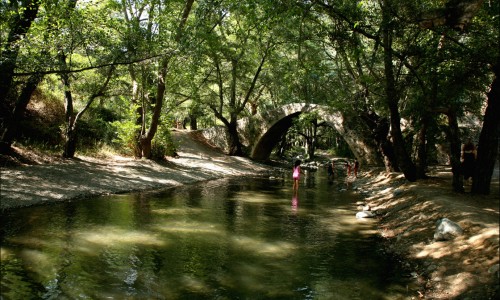
The Vasilikos River is situated in the village of Kalavasos in the Larnaca district. More specifically it is located about 40 kilometres from the town of Larnaca at an average altitude of about 80 metres.

The Vasilikos River extends from the Larnaca mountains until the village of Zygi at the south part of Cyprus. The river has a depth ranging from 2 to 8 metres.

The river has been linked with legends and traditions from antiquity as well as tragic incidents in modern history. According to tradition , a storm forced Agia Eleni to moor at the south coast of Cyprus , as she was returning from her visit to Jerusalem. She had stopped at the banks of the anicent Tetio River which was later on named Vasilopotamos or Vasilikos River in honour of the king's mother.

Vasilikos River photos: 
vasilikos river
vasilikos river
Vasilikos River location map: 

Nearby Places and things to do (within 5 km radius)

Kannavia

Kannavia is a village which located in the district of Nicosia about 52 kilometres northwest from the capital city. The village is buil...

Agia Irene - Limeria Nature Trail

Location: Agia Irene Village District: Nicosia Starting Point: Agia Irene Village. At the location Selladi tis Straorouthkias there ...

Selladi tou Karamanli - Kannavia Nature Trail

Location: Selladi tou Karamanli –Saranti – Spilia –Kannavia District: Nicosia Starting Point: Selladi tou Karamanli on the road...

Panagia Chrysokourdaliotissa church

Panagia Chrysokourdaliotissa church can be described as a beautiful medieval church located in the natural environment of Cyprus. The church...

Kourdali - Limeria Nature Trail

Location: Kourdali Village District: Nicosia Starting Point: Kourdali Village. At the location Selladi tis Straorouthkias there is ac...

Spilia and Kourdali Village

The history of Spilia and Kourdali began from the 16th century. That is when the church of Panagia Chrysokourdaliotissa which was in the cen...

Pages